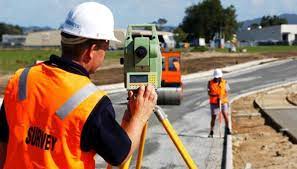
Civil surveyor course in Islamabad
The Civil Surveyor Training Program is designed to equip individuals with the essential skills and knowledge required to excel in the field of land surveying within the civil engineering domain. This comprehensive course covers a wide range of topics related to land measurement, mapping, data collection, and geospatial technology. Participants will gain hands-on experience with cutting-edge surveying instruments and software tools, preparing them for a successful career as civil surveyors.
Course Benefits:
- In-Demand Skillset: Land surveying is an integral part of civil engineering projects. Graduates of this program will possess the skills demanded by industries involved in construction, infrastructure development, urban planning, and more.
- Hands-on Experience: The course includes practical training sessions where students will have the opportunity to work with modern surveying equipment and software, ensuring they are well-prepared for real-world challenges.
- Career Opportunities: Upon completing the program, graduates can pursue roles such as land surveyor, field survey technician, GIS analyst, mapping specialist, or even advance to project management positions.
- Industry Relevance: The curriculum is developed in collaboration with industry experts to ensure that students learn the latest techniques and technologies used in the field.
- Networking: Students will have the chance to interact with professionals from the industry through guest lectures, workshops, and site visits, helping them build valuable connections.
- Practical Projects: The course involves various practical projects where students will apply their knowledge to real-world scenarios, enhancing their problem-solving and critical thinking abilities.
Course Learning Outcomes:
By the end of the Civil Surveyor Training Program, participants will be able to:
- Demonstrate proficiency in using advanced surveying instruments and software.
- Conduct accurate land measurements, boundary surveys, and topographic surveys.
- Create detailed maps, plans, and elevation profiles using geospatial technology.
- Analyze survey data, identify errors, and apply corrective measures.
- Interpret legal and cadastral principles related to land ownership and boundaries.
- Collaborate effectively with multidisciplinary teams on construction and development projects.
- Apply ethical and professional standards in surveying practices.
- Adapt to emerging technologies and trends within the field of land surveying.
Course Study Units:
- Introduction to Surveying:
- Fundamentals of surveying
- Types of surveys: land, engineering, construction, etc.
- Surveying instruments: theodolites, total stations, GPS, etc.
- Geospatial Technology:
- Geographic Information Systems (GIS)
- Remote sensing and aerial photography
- Global Positioning System (GPS) principles
- Legal and Cadastral Surveying:
- Land ownership and boundaries
- Deeds, titles, and land registration
- Cadastral survey methodologies
- Data Collection and Analysis:
- Field data collection techniques
- Data accuracy and error analysis
- Digital terrain modeling and contour mapping
- Topographic Surveys:
- Measuring ground elevation and features
- Digital mapping and contour generation
- Profile and cross-section creation
- Construction Surveying:
- Site layout and setting out
- As-built surveys and monitoring
- Quantity and volume calculations
- Geodetic Surveying:
- Earth’s shape and coordinate systems
- State plane and UTM coordinate systems
- Geodetic control networks
- Professional Ethics and Communication:
- Ethical considerations in surveying
- Effective communication within a team
- Client interaction and reporting
Entry Requirements:
- High school diploma or equivalent.
- Basic understanding of mathematics, geometry, and trigonometry.
- Proficiency in using computers and software applications.
Future Progressions: Upon successful completion of the Civil Surveyor Training Program, graduates can explore several pathways for future growth:
- Pursue a bachelor’s degree in civil engineering, geomatics, or related fields.
- Obtain certifications in specialized surveying software or technologies.
- Gain experience as a surveying technician or field assistant to enhance practical skills.
- Advance to project management roles within the surveying or civil engineering industry.
- Engage in continuing education and professional development to stay updated with industry advancements.
Conclusion:
the Civil Surveyor Training Program offers a comprehensive curriculum that combines theoretical knowledge with practical skills, ensuring that participants are well-prepared to enter the dynamic field of land surveying within the civil engineering sector. With a focus on industry relevance, hands-on experience, and networking opportunities, this program provides a solid foundation for a rewarding and successful career in the surveying industry.